Once you download and install Google Earth, your computer becomes a window to anywhere, allowing you to view high-resolution aerial and satellite imagery, photos, elevation terrain, road and street labels, business listings, and more.
Getting to Know Google Earth
The following diagram describes some of the features available in the main window of Google Earth:
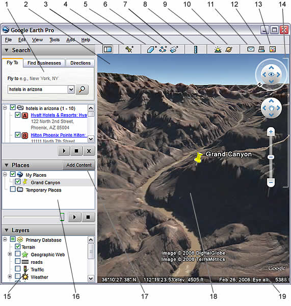
- Search panel - Use this to find places and directions and manage search results. Google Earth EC may display additional tabs here.
- Overview map - Use this for an additional perspective of the Earth.
- Hide/Show sidebar - Click this to conceal or the display the side bar (Search, Places and Layers panels).
- Placemark - Click this to add a placemark for a location.
- Polygon - Click this to add a polygon.
- Path - Click this to add a path (line or lines).
- Image Overlay - Click this to add an image overlay on the Earth.
- Measure - Click this to measure a distance or area size.
- Email - Click this to email a view or image.
- Print - Click this to print the current view of the Earth.
- Show in Google Maps - Click this to show the current view in Google Maps in your web browser.
- Sky - Click this to view stars, constellations, galaxies, planets and the Earth's moon.
- Navigation controls - Use these to tilt, zoom and move around your viewpoint (see below).
- Layers panel - Use this to display points of interest.
- Places panel - Use this to locate, save, organize and revisit placemarks.
- Add Content - Click this to import exciting content from the KML Gallery
- 3D Viewer - View the globe and its terrain in this window.
- Status bar - View coordinate, elevation and imagery streaming status here.

Tidak ada komentar:
Posting Komentar